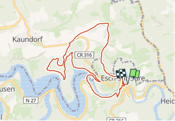
![](/images/other/stat-length.png)
![Tour Wandern Esch an der Sauer - 2023-07-03_11h12m49_autopedestre-esch-sur-sure - Photo](https://media.geolcdn.com/t/1900/400/ext.pjpeg?maxdim=2&url=https%3A%2F%2Fstatic1.geolcdn.com%2Fsiteimages%2Fupload%2Ffiles%2F1553511878bg_sport_marche.png)
2023-07-03_11h12m49_autopedestre-esch-sur-sure
mumu.larandonneuse
Benutzer GUIDE
![Länge](/images/other/stat-length.png)
![Maximale Höhe](https://static1.geolcdn.com/siteimages/upload/files/1508320355ic_sort_altitude_max_24dp.png)
![Positive Höhendifferenz](https://static1.geolcdn.com/siteimages/upload/files/1508320355ic_sort_den_pos_24dp.png)
![Km-Effort](/images/other/stat-length.png)
![Min. Höhe](https://static1.geolcdn.com/siteimages/upload/files/1508320355ic_sort_altitude_min_24dp.png)
![Negative Höhendifferenz](https://static1.geolcdn.com/siteimages/upload/files/1508320355ic_sort_den_neg_24dp.png)
![Boucle](https://static1.geolcdn.com/siteimages/upload/files/16400158638029165_repeat_loop_refresh_sync_direction_icon.png)
![Wandern](https://static1.geolcdn.com/sitytour/trail-icons/101.png)
3h23
Schwierigkeit : Medium
![Scannen Sie diesen QR-Code, um die Tour in der SityTrail-Anwendung zu öffnen](https://capi.geolives.com/qq0zvz2zws4bq2lad0pu/sitytour/trails/3720901/qr.png?size=200)
Kostenlosegpshiking-Anwendung
Über SityTrail
Tour Wandern von 9,7 km verfügbar auf Unbekannt, Kanton Wiltz, Esch an der Sauer. Diese Tour wird von mumu.larandonneuse vorgeschlagen.
Beschreibung
ℹ️ visiteislek.lu
➡️ L'Auto-Pédestre Esch-sur-Sûre s'étend au nord-est de la petite ville idyllique, jusqu'au réservoir de la Haute-Sûre et sur les collines boisées environnantes.
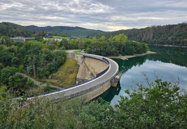
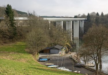
L'Auto-Pédestre Esch-sur-Sûre commence sur un parking juste à l'extérieur du village. Il vous emmène d'abord à travers le village, puis le long des rives de la Sauer, en passant devant l'ancienne usine de draps et jusqu'au barrage voûte de 47 mètres de haut. Il a été construit de 1955 à 1958. Son épaisseur de paroi est d'environ 1,5 m en haut et d'environ 4,5 mètres en bas. Le chemin continue vers les collines boisées autour du réservoir d'Obersauer. Cela sert non seulement de beau spectacle naturel, mais aussi de réserve d'eau potable et de production d'électricité.
Du sommet, vous pourrez admirer de superbes vues sur le réservoir, dont l'apparence change constamment au fil des saisons.
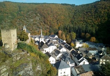
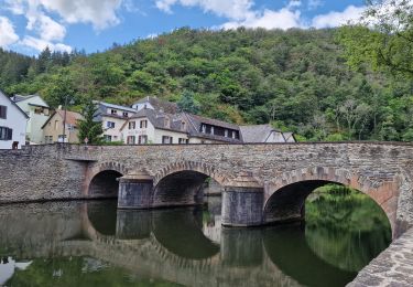
Le chemin vous emmène presque jusqu'à Kaundorf, où il fait demi-tour pour vous ramener lentement à Esch-sur-Sûre. A partir de maintenant, c'est toujours en descente, puis à travers la ville idyllique et devant les ruines du château médiéval, retour au point de départ.
.
Ort
Kommentare
Touren in der Umgebung
![Tour Wandern Esch an der Sauer - 2023-08-23_09h43m26_circuit-du-lac-partie-est - Photo](https://media.geolcdn.com/t/375/260/619555c4-ff7c-4941-9e77-0e4407bce06b.jpg&format=jpg&maxdim=2)
![Wandern Wandern](https://static1.geolcdn.com/sitytour/trail-icons/101.png)
Wandern
![](/images/other/stat-length.png)
![](https://static1.geolcdn.com/siteimages/upload/files/16400158638029165_repeat_loop_refresh_sync_direction_icon.png)
![Tour Wandern Esch an der Sauer - 2017-10-15 - Photo](https://media.geolcdn.com/t/375/260/ext.jpg?maxdim=2&url=https%3A%2F%2Fservices.sitytrail.com%2FGeolivesWS%2FDownloadMedia.ashx%3FTrailID%3D846504%26Media%3Dfix__20171015113007.jpg)
![Wandern Wandern](https://static1.geolcdn.com/sitytour/trail-icons/101.png)
Wandern
![](/images/other/stat-length.png)
![](https://static1.geolcdn.com/siteimages/upload/files/16400158638029165_repeat_loop_refresh_sync_direction_icon.png)
![Tour Wandern Stauseegemeinde - Autopedestres : Liefrange - Photo](https://media.geolcdn.com/t/375/260/ext.jpg?maxdim=2&url=https%3A%2F%2Fstatic1.geolcdn.com%2Fsiteimages%2Fupload%2Ffiles%2F1553511878bg_sport_marche.png)
![Wandern Wandern](https://static1.geolcdn.com/sitytour/trail-icons/101.png)
Wandern
![](/images/other/stat-length.png)
![](https://static1.geolcdn.com/siteimages/upload/files/16400158638029165_repeat_loop_refresh_sync_direction_icon.png)
![Tour Wandern Goesdorf - Autopedestres : Dahl - Photo](https://media.geolcdn.com/t/375/260/ext.jpg?maxdim=2&url=https%3A%2F%2Fstatic1.geolcdn.com%2Fsiteimages%2Fupload%2Ffiles%2F1553511878bg_sport_marche.png)
![Wandern Wandern](https://static1.geolcdn.com/sitytour/trail-icons/101.png)
Wandern
![](/images/other/stat-length.png)
![](https://static1.geolcdn.com/siteimages/upload/files/16400158638029165_repeat_loop_refresh_sync_direction_icon.png)
![Tour Zu Fuß Goesdorf - FB Goesdorf - Photo](https://media.geolcdn.com/t/375/260/d2f594e0-9639-4ea9-80de-72a6a1e4316d.jpeg&format=jpg&maxdim=2)
![Zu Fuß Zu Fuß](https://static1.geolcdn.com/sitytour/trail-icons/100.png)
Zu Fuß
![](/images/other/stat-length.png)
![](https://static1.geolcdn.com/siteimages/upload/files/16400158638029165_repeat_loop_refresh_sync_direction_icon.png)
![Tour Zu Fuß Stauseegemeinde - Fleche Bleu Lifrange - Photo](https://media.geolcdn.com/t/375/260/64be2f19-2efe-4776-8b68-43645c83d5ce.jpeg&format=jpg&maxdim=2)
![Zu Fuß Zu Fuß](https://static1.geolcdn.com/sitytour/trail-icons/100.png)
Zu Fuß
![](/images/other/stat-length.png)
![](https://static1.geolcdn.com/siteimages/upload/files/16400158638029165_repeat_loop_refresh_sync_direction_icon.png)
![Tour Zu Fuß Goesdorf - Fleche Bleu Dahl - Photo](https://media.geolcdn.com/t/375/260/ad8287c0-d1a6-40ea-ba0a-97f53e50a748.jpeg&format=jpg&maxdim=2)
![Zu Fuß Zu Fuß](https://static1.geolcdn.com/sitytour/trail-icons/100.png)
Zu Fuß
![](/images/other/stat-length.png)
![](https://static1.geolcdn.com/siteimages/upload/files/16400158638029165_repeat_loop_refresh_sync_direction_icon.png)
![Tour Wandern Esch an der Sauer - Esch-sur-Sûre (PVDB) - Photo](https://media.geolcdn.com/t/375/260/58089398-3985-484c-8873-bf5b143c43e6.jpg&format=jpg&maxdim=2)
![Wandern Wandern](https://static1.geolcdn.com/sitytour/trail-icons/101.png)
Wandern
![](/images/other/stat-length.png)
![](https://static1.geolcdn.com/siteimages/upload/files/16400158638029165_repeat_loop_refresh_sync_direction_icon.png)
![Tour Wandern Esch an der Sauer - 2023-06-19_15h18m29_eislek-pad-tadler-1 - Photo](https://media.geolcdn.com/t/375/260/ext.jpg?maxdim=2&url=https%3A%2F%2Fstatic1.geolcdn.com%2Fsiteimages%2Fupload%2Ffiles%2F1553511878bg_sport_marche.png)
![Wandern Wandern](https://static1.geolcdn.com/sitytour/trail-icons/101.png)
Wandern
![](/images/other/stat-length.png)
![](https://static1.geolcdn.com/siteimages/upload/files/16400158638029165_repeat_loop_refresh_sync_direction_icon.png)